
3D Maps
How to use AYNIcam’s 3D driving map on iPhone
Set up AYNIcam’s 3D Maps, adjust zoom, recenter, find a destination and check weather. Learn where the buildings and detected objects come from.
In this guide
What the 3D map shows
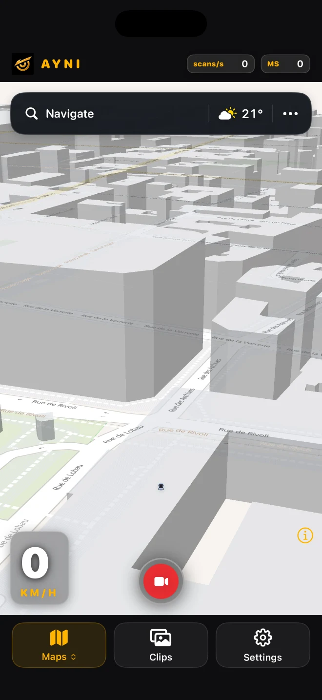
AYNIcam combines mapped roads and buildings with approximate positions of supported camera detections. The buildings come from map data, not a building-recognition camera model. Coverage and building detail depend on the mapped area. This guide describes the current development build; check App Store release notes for availability.
Set up before driving
Mount your iPhone securely with a clear forward view. Open AYNIcam, grant camera and location permissions as needed, and select Maps from the view picker. Maps is available in Free and Pro with the detector models. The Pro segmentation model opens a separate Perception page instead.
Zoom and return to your position
Pinch the map to change how much of the street you see. The automatic driving view gradually opens up as speed rises and moves closer as you slow down. Panning or rotating lets you explore; use the recenter control to return to the driving view. Configure the view while safely stopped.
Search for your destination
Use Navigate in the upper bar to search for a place and request an itinerary. MapKit supplies destination search and directions. A network connection is needed; route availability and timing depend on the provider. Navigation is guidance, not a guarantee that a road is open or safe.
Check weather from the map
Tap the weather chip to open current conditions and forecast information. Weather comes from online services and is refreshed periodically, so it is not an instant reading of the road in front of the camera. Follow local weather warnings and actual road conditions.
Keep recording within reach
The red video button saves the available rolling-buffer footage before your tap. Free supports up to 20 seconds at 720p in driving context; Pro supports up to 30 seconds at 1080p, including while stopped. Pro audio needs microphone permission. Review saved recordings in Clips when safe.
Know what is an estimate
Single-camera distance, object placement and body direction can be uncertain. A mapped building may be missing or out of date; an object can be missed or incorrectly placed. Simulator screenshots demonstrate the controls, not real traffic accuracy. AYNIcam does not steer, brake or replace attention and parking sensors.
Manage power and connectivity
Use the app’s Power Saver when appropriate, keep the phone away from direct sun and watch device temperature. The app adapts workload to power and thermal conditions; no fixed scan rate or frame rate is guaranteed. Detection and recording work locally, while maps, routing and weather use online services.